위더스도르프 최고의 러닝 경로
4.4
(818)
3,944
달리기 하는 사람
242
러닝
위더스도르프에서 하이킹하며 불카네이펠 구석 부분까지 살펴볼까요? 위더스도르프에 있는 모든 하이킹 및 워킹 경로 컬렉션 중 가장 멋진 하이킹 경로를 엄선하여 소개해드릴게요. 다른 하이커가 공유한 실제 팁과 사진을 살펴보고 후기를 읽으며 마음에 드는 위더스도르프 워킹 경로를 찾아보세요.
마지막 업데이트: 10월 13, 2026
4.0
(8)
38
달리기 하는 사람
8.52km
01:04
280m
280m
보통 조깅. 좋은 체력 필요. 대부분 포장된 지면. 실력과 관계없이 누구나 갈 수 있음.
4.9
(7)
48
달리기 하는 사람
5.23km
00:34
90m
90m
보통 조깅. 좋은 체력 필요. 대부분 포장된 지면. 실력과 관계없이 누구나 갈 수 있음.

4.8
(4)
37
달리기 하는 사람
25.4km
02:45
380m
380m
어려운 조깅. 우수한 체력 필요. 대부분 포장된 지면. 실력과 관계없이 누구나 갈 수 있음.
5.0
(1)
20
달리기 하는 사람
13.6km
01:33
330m
330m
어려운 조깅. 우수한 체력 필요. 대부분 포장된 지면. 실력과 관계없이 누구나 갈 수 있음.
2.0
(1)
11
달리기 하는 사람
26.8km
03:06
460m
460m
어려운 조깅. 우수한 체력 필요. 튼튼한 신발을 신고 미끄러지지 않게 조심해야 하며, 높은 산을 오른 경험이 있어야 함.
더 다양한 경로와 다른 탐험가들의 추천을 살펴보세요.
이미 komoot 계정이 있나요?
투어 추천은 다른 사람들이 komoot에서 완료한 수천 개의 활동을 바탕으로 구성되어 있습니다.




커뮤니티 팁

Nice start for the 12th Eifelsteig stage from Manderscheid to Himmerod
0
0

Eifelsteig stage 12 passes at this point. https://youtu.be/EGc9DxGhyIM
0
0

"Old Station" Schalkenmehren Passenger service between Daun and Wittlich was discontinued on November 1, 1981. Schalkenmehren. Approaching the Old Station in Schalkenmehren on the former railway line, today's Maare-Mosel cycle path, and seeing the station building, it's hard to believe that it was opened as a fourth-class railway station exactly 100 years ago. But how did it all begin 100 years ago? Surveying for the Daun-Wittlich railway line began as early as 1897. General preparatory work for the single-track line began in 1907. But it would take some time before the Daun-Schalkenmehren-Gillenfeld section opened on December 1, 1909, with the line running over the 28-meter-high Daun viaduct and through the 560-meter-long Schalkenmehren railway tunnel, "Großes Schlitzohr" (Great Sly Fox). The extension from Gillenfeld to Manderscheid to Pantenburg was completed on May 1, 1910, and the extension from Manderscheid-Pantenburg to Wittlich, signifying the completion of the entire line, was completed on July 1, 1910. The completion of the Daun-Wittlich railway line brought rapid development to the village of Schalkenmehren. In the first year of the line's existence (1910), 18,968 tickets were sold in Schalkenmehren, followed by 25,057 in 1913, 27,969 in 1919, and even 30,279 in 1922. In addition, Schalkenmehren station was designed for general cargo traffic and the receipt and dispatch of wagonloads. Text / Source: www.volksfreund.de/ https://www.volksfreund.de/region/vulkaneifel/ein-schmuckstueck-fuer-nostalgiker_aid-5712448
15
0

beautiful fountain in the middle of Manderscheid
0
0

In the wooded section between the Lieser and Gemünden Maar lakes, hikers and walkers encounter a war memorial. The complex is constructed of stone in a comparatively large semicircle, but the overall appearance leaves me somewhat perplexed: Only the middle of the seven sections created by the vertical structure of the memorial bears a plaque. On the others—three on each side, which, like a window, offer a view of the treetops behind—I would have expected similar plaques, mostly listing the names of the victims who lost their lives in the two terrible world wars in the first half of the last century.
2
0

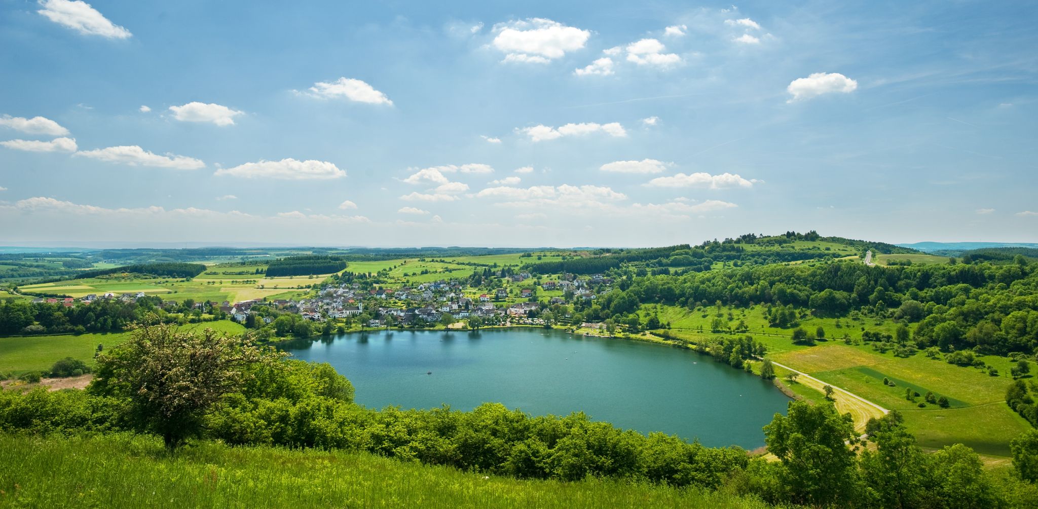
From the hills around the Schalkenmehrener Maar you have different views of the village and the almost circular water surface. One view is more beautiful than the other. Sometimes you see the St. Martin Church reflected in the water, or you can see a dry maar or the adjacent maar with fen.
2
0

The fountain, created by the Eifel artist Johann Baptist Lenz, stands on the forecourt of the former municipal administration (from 2018, the doctors' center). The fountain is set into depressions in the forecourt floor, next to it in the form of a tree, which is decorated with words of wisdom, sayings, etc. and which children climb. In front of it is a figure in uniform and spiked helmet, probably a municipal police officer from the Prussian era. The so-called "criers" or "criers" existed in every village until the end of the 1950s. If the administration or the local mayor had something to announce, the municipal servant walked through the village with a bell, stopped at prominent points, rang his bell and read out the official announcement. In some villages, people held "Gemeen" (congregation) and announced the news after Sunday mass on the church square copied from: https://kulturdb.de/einobjekt.php?id=39069
1
0

The Niederburg can be explored with guided tours - even at night - or on your own; it is only closed in bad weather. It was expanded into a magnificent, fortified seat of power in the 12th century by the noble family of the Lords of Manderscheid. Source: https://www.eifel.info/a-manderscheider-burgen
55
0
위더스도르프 주변에서 가장 인기 있는 명소


더 살펴보기
다른 지역의 최고의 러닝 트레일 & 경로를 살펴보세요.
