경로

플래너

기능

업데이트

App

로그인 또는 가입

앱 다운로드

로그인 또는 가입

경로
Places to see
이탈리아
아브루초
키에티

도글리올라

10의 도글리올라가지 명소 & 주요 장소


도글리올라에는 둘러볼 만한 장소가 많답니다. 하이킹 또는 사이클링을 좋아한다면 도글리올라에 숨겨진 10
가지 보석을 만날 수 있을 거예요. 이 지역의 주요 명소를 살펴보면서 다음 모험을 계획해보세요.

마지막 업데이트: 7월 14, 2026

칼란키 전망

하이라이트 • 전망대

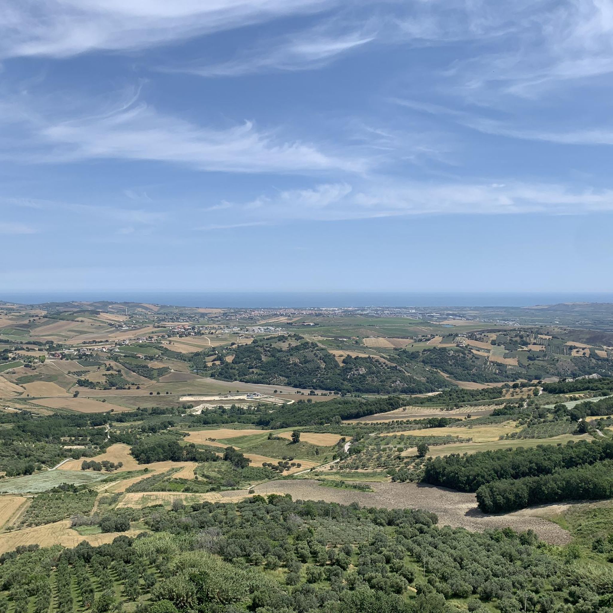
From this stretch of the provincial road you can enjoy the view towards the village of Montenero di Bisaccia and the Calanchi di Montenero, an area of about 120 hectares, …

번역자 Google •

에 의해

하이킹 보기

휴대폰으로 전송

저장

Montenero di Bisaccia

하이라이트 • 정착지

Montenero di Bisaccia is a town in Molise located on a hill 10 km from the sea and the Trigno river. It is possible to visit the Mother Church, the …

번역자 Google •

에 의해

저장

이런 장소를 발견하려면 지금 가입하세요

최고의 싱글 트랙, 봉우리 및 다양한 흥미로운 야외 장소에 대한 추천을 받아보세요.

무료 회원 가입

dirt road with single track that connects Madonna Stadium at the crossroads for Palata

번역자 Google •

에 의해

저장

토레 델라 파라

하이라이트 • 역사적 장소

The Torre della Fara is located in Torre della Fara in the municipality of Celenza sul Trigno in the province of Chieti. The tower is located near the Trigno river …

번역자 Google •

에 의해

저장

According to oral tradition, it seems that San Michele, who left from the East to defeat paganism, stopped in a wood near Liscia before arriving on the Gargano; this wood …

번역자 Google •

에 의해

저장

무료로 가입하여 도글리올라 주변의 더 많은 명소를 발견하세요.

무료 회원 가입

이미 komoot 계정이 있나요?

오늘 무료 계정으로 시작하세요

다음 모험이 기다리고 있어요.
로그인 또는 가입하기

도글리올라 주변 인기 장소

도글리올라 하이킹

도글리올라 로드 사이클링 경로

도글리올라 사이클링

도글리올라 MTB 트레일

커뮤니티 팁

Niccolo13
6월 21, 2026, Vista sui calanchi

공사로 인한 도로 차단

번역: Google

0

0

The Montenero di Bisaccia gullies, known locally as lame, are located behind the Sanctuary of the Madonna di Bisaccia. The area is characterized by erosive landforms that extend over approximately 120.8 hectares, creating a surreal landscape of deep valleys dominated by thin, jagged ridges.

번역: Google

0

0

Drinking water

번역: Google

0

0

Through the Calanchi of Montenero di Bisaccia

번역: Google

0

0

The Torre della Fara is located in Torre della Fara in the municipality of Celenza sul Trigno in the province of Chieti. The tower is located near the Trigno river and the Ateleta-Biferno sheep track and was in visual connection with neighboring towns and with the monastery of Santa Maria del Canneto of Roccavivara (Molise). (Source Wikipedia.)

번역: Google

1

0

From this stretch of the provincial road you can enjoy the view towards the village of Montenero di Bisaccia and the Calanchi di Montenero, an area of about 120 hectares, where there are erosive forms created by the action of rainwater on the clayey soil. The area is a site of community interest (SIC), identified by the Ministry of the Environment for its naturalistic and landscape importance.

번역: Google

3

1

Montenero di Bisaccia is a town in Molise located on a hill 10 km from the sea and the Trigno river. It is possible to visit the Mother Church, the Municipal Palace and just outside the historic centre, the Sanctuary of Maria Santissima di Bisaccia.

번역: Google

2

0

The Torre della Fara is located in Torre della Fara in the municipality of Celenza sul Trigno in the province of Chieti. The tower is located near the Trigno river and the Ateleta-Biferno tratturo and was in visual connection with neighboring towns and with the monastery of Santa Maria del Canneto in Roccavivara (Molise). The tower dates back to the 12th century.[1] Even if the toponym recalls the Longobard fara, it is, however, difficult to identify the period of construction of the site.[ The tower has a cylindrical structure and is made of stone[1], but stone fragments are also used to frame the openings and loopholes[2]. The tower is 15 meters high and 6 meters in diameter. The tower has no scarp walls and, at a third of the height there is an opening which, probably, is a raised entrance. Furthermore, inside there are the holes where the beams used to support the various levels. The roof inside is vaulted with a lowered cap. The use of mortar in the Torre della Fara decreases with height[1] just as the thickness of the walls decreases with increasing height

번역: Google

0

0

도글리올라 주변에서 가장 인기 있는 경로

도글리올라 하이킹

Store rating

komoot 모바일 앱으로 영감을 받아보세요

무료 komoot 계정로 끝없는 야외 모험을 손쉽게 찾고, 맞춤 설정하며 길안내할 수 있어요.

또는

지금 komoot에 가입하세요

Store rating

더 살펴보기

찾고 있는 하이라이트를 아직 못 찾으셨나요? 다른 지역의 주요 명소 가이드를 확인해보세요:

포세시아트레글리오산 비토 키에티노란치아노오르토나프리사페나피에디몬테로카 산 조반니산타 마리아 임바로프레토로모짜그로냐토리노 디 산그로라피노라마 데이 펠리니과디아그렐레파글리에타빌라폰시나파라 산 마르티노시비텔라 메서 라이몬도레토팔레나팔롬바로크레키오산 마르티노 술라 마루치나타란타 펠리그나카살보르디노파라 필리오룸 페트리로카몬테피아노카사칸디텔라톨로카솔리카노사 산니타팔레나몬테오도리시오세르니바스토오염필레토밀리아니코프랑카빌라 알 마레부키아니코포지피오리토오르소냐콜레디머신카사린콘트라다감베랄레줄리아노 테아티노피조페라토산살보큐펠로몬테네로도모산 조반니 테아티노리파 티티나토레베키아 티티나푸르시게소팔레나토리첼라 펠리그나빌라마냐로카스칼냐바크리기씨시비탈루파렐라빌라 산타 마리아아리렌텔라로젤로산테우사니오 델 상그로카스텔 프렌타노보렐로아테사페나도모카스틸리오네 메서 마리노쿼드리로이오 델 상그로아리엘리봄바몬테라피아노콜레디메조프레자그란디나리아몬테벨로 술 상그로팔로스키아비 다브루초알티노아치카스텔귀돈토르나레치오팔몰리토레브루나카사랑귀다페라노몬타졸리Riserva Naturale Regionale Di Punta Aderci몬테페란테산 조반니 리피오니산 부오노셀렌자 술 트리뇨로카스피날베티카룬키오프레인투필로Riserva Naturale Regionale Della Lecceta Di Torino Di Sangro

근처 어드벤처 가이드

투필로 즐길거리

background

새로운 정복을 위한 준비를 하세요

무료로 가입하기

탐험하기
경로경로 플래너기능하이킹MTB 트레일로드 사이클링 경로바이크패킹사이트맵
앱 다운로드
소셜 미디어에서 팔로우하기

© komoot GmbH

개인 정보 보호 정책