Timeline
Churfranken planned a hike
June 13, 2025
Time
Distance
Speed
Ascent
Descent
Silvi 🌺 and Achim Weikinger like this.
Churfranken planned a hike
June 13, 2025
Time
Distance
Speed
Ascent
Descent
Silvi 🌺 and Achim Weikinger like this.
October 27, 2022
Leaving the ruins of the Henneburg, the path leads almost flat past the former vineyard terraces in the direction of Faulbach. Arriving at the summit, the view falls on Faulbach and in front of it on a hill rising up in the middle of the valley. It is a "circulating mountain", which means that the Main
Translated by Google •
Churfranken and Bayern Tourismus planned a hike
November 22, 2024
Time
Distance
Speed
Ascent
Descent
February 10, 2022
Since 1990, the Franconian Red Wine Hiking Trail has connected the vineyards in Churfranken and is the ideal option for leisurely hikers, true to the motto: Live slowly.
It stretches 79 kilometers from the wine-growing community of Großwallstadt in the north to the designated stronghold of brilliant Pinot
Translated by Google •
Churfranken planned a hike
August 19, 2024
Time
Distance
Speed
Ascent
Descent
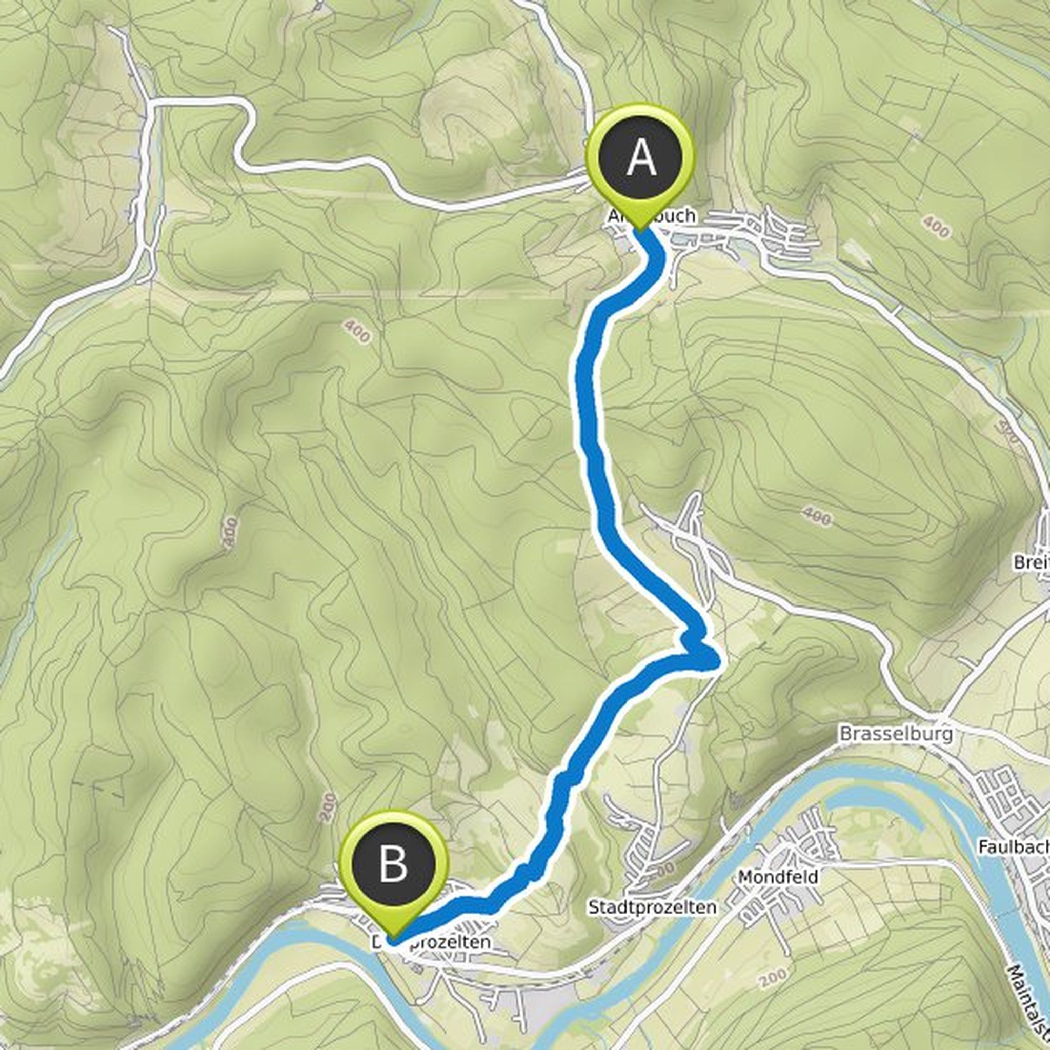
October 27, 2022
The adventure trail along the Main between Spessart and Odenwald runs for around 40 kilometers from Miltenberg via Bürgstadt, Collenberg, Dorfprozelten, Stadtprozelten to Faulbach.
The quarries that shape the landscape, as well as the architectural, artistic and cultural monuments in the towns on the
Translated by Google •
Churfranken planned a hike
August 19, 2024
Time
Distance
Speed
Ascent
Descent
Silvi 🌺 and Achim Weikinger like this.
October 27, 2022
The trail section starts at the train station and leads through meadow orchards, fields and a ravine to the forest. Keeping right at the fork in the road, leave the "Marienweg" and turn right into the deciduous forest in front of a raised hide. The winding path leads to the edge of the quarry, where
Translated by Google •
Churfranken planned a hike
August 19, 2024
Time
Distance
Speed
Ascent
Descent
Silvi 🌺 and Achim Weikinger like this.
October 27, 2022
The path leaves the district of Fechenbach, past the cemetery and, accompanied by the modern Way of the Cross, leads along the slope to the Kollenberg castle ruins, the special features of which are described on a separate information board. Halfway, the "Marienruhe" invites you to take a look, rest
Translated by Google •
Churfranken planned a hike
October 27, 2022
Time
Distance
Speed
Ascent
Descent
Silvi 🌺 and Achim Weikinger like this.
October 27, 2022
The section of the trail starts at the new Main Bridge and leads along a gallery of quarries, most of which have been under nature protection since 1983. This landscape is known in the maps and in the vernacular as "Mainhelle" or "Mainhölle". A term that is likely to be derived from the bright, luminous
Translated by Google •
Churfranken planned a hike
October 27, 2022
Time
Distance
Speed
Ascent
Descent
Gerald, Silvi 🌺 and Achim Weikinger like this.
October 27, 2022
The cycle path leads to the pedestrian bridge over the Erf and back to the river bank. It leads past the derrick crane, which was used in the quarries and workshops to move and load heavy blocks and workpieces and, after its restoration in 2022, will find a new place at a historic location near the old
Translated by Google •
Churfranken planned a hike
October 27, 2022
Time
Distance
Speed
Ascent
Descent
Gerald, Silvi 🌺 and Achim Weikinger like this.
October 27, 2022
From the starting point at the car park at the "Schwertfegertor" it is worth the short return trip to the city entrance marked by the "Mainzer Tor", because there the old, three-arch mud bridge shows mediaeval bridge architecture and the Laurentius chapel and the cemetery are cultural-historical and
Translated by Google •
Churfranken planned a hike
February 21, 2022
Time
Distance
Speed
Ascent
Descent
February 21, 2022
At the SV Faulbach sports grounds, after about 100 meters, there is a small car park in the forest on the right-hand side. The car is parked there. The path now follows the sign Marienweg/Keiler to the right. After about 300 meters the path leads to the left. After 1 kilometer a gravel road is crossed
Translated by Google •
Churfranken planned a hike
February 11, 2022
Time
Distance
Speed
Ascent
Descent
February 21, 2022
A circular route around the Grohberg nature reserve with a view of the Main valley, Stadtprozelten with the Henneburg, Faulbach with its lock and the hills on the Baden side of the Main.
Botanical highlights: the rare Carthusian carnations and the sand thrift bloom in the meadows from April to October
Translated by Google •
Churfranken planned a hike
February 11, 2022
Time
Distance
Speed
Ascent
Descent
Thomas & Manuela Sauerwein, Achim Weikinger and Al Fried like this.
February 21, 2022
Starting from the signpost ''Am Weiher'' in Neuenbuch, we follow the course of path S1 to the left and after about 1 km we reach the hiker's hut ''am Sohl''. On the Spessart Nature Park hiking board there, our further path is described under number 2. We therefore follow the Spessartweg 2 and after about
Translated by Google •
Churfranken planned a hike
February 11, 2022
Time
Distance
Speed
Ascent
Descent
February 21, 2022
From the main road, walking a few meters along the forest road, the paved driveway marked with the A2 branches off at the children's playground.
After about 350 m, turning right, a ravine in the lower part leads almost continuously uphill to the Sylvan forester's lodge. The forest house is currently uninhabited
Translated by Google •
Churfranken planned a hike
February 11, 2022
Time
Distance
Speed
Ascent
Descent
Kohlmann, Thomas & Manuela Sauerwein and Achim Weikinger like this.
February 21, 2022
When the Spessart valleys were settled in the Middle Ages, very few of the new villages received their own parish. If someone had died and a funeral was due, you had to go to the nearest church, where there was a cemetery.
For many hundreds of years, the old books had to make the arduous journey of about
Translated by Google •
Churfranken planned a hike
February 11, 2022
Time
Distance
Speed
Ascent
Descent
February 21, 2022
Beautiful path with a view of the Main, the ruins of Kollenburg and a war memorial chapel
Follow the "D1" marking to the Steingasse signpost and from here steeply uphill along the Franconian Marienweg. At the top (signpost) turn left and head west above the stone bridge. There is a small cul-de-sac that
Translated by Google •
October 27, 2022
The path leaves Dorfprozelten and leads past the vineyards following the "Franconian Marienweg" to the "Wegstein" on the Bichlberg and from there to the idyllic Sellgrund with the refuges. Following the road to the right, you will reach Stadtprozelten. The "Three Crosses" are located directly at the
Translated by Google •