아존 주변 최고의 교통량 없는 자전거 라이딩 코스
4.4
(342)
5,375
자전거 타는 사람
70
라이딩
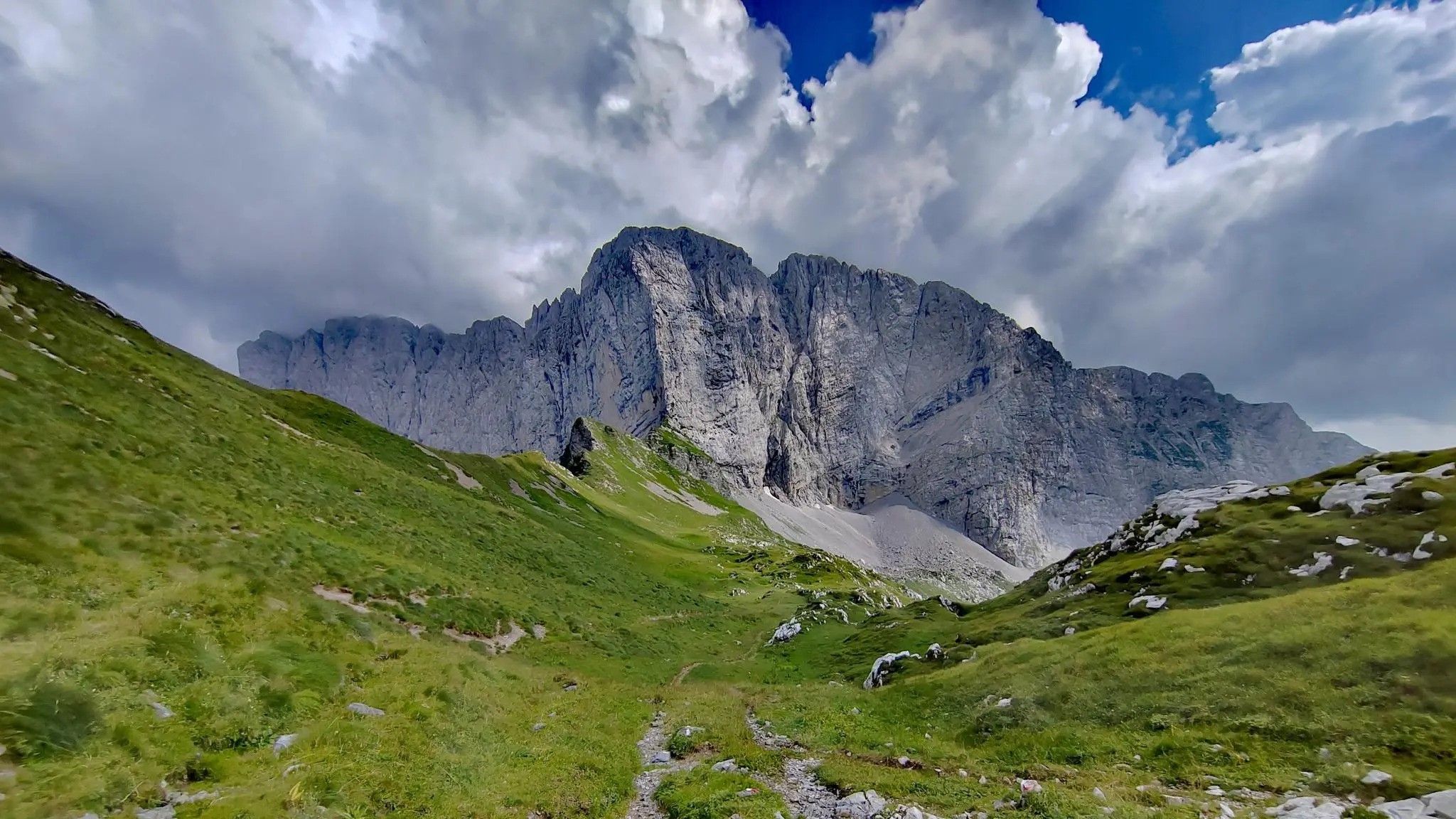
교통량 없는 투어링 자전거 코스는 이탈리아 오로비에 알프스의 극적인 풍경, 특히 발 디 스칼베(Val di Scalve) 지역에 자리 잡고 있습니다. 이 지역은 프레솔라나(Presolana)와 치몬 델라 바고차(Cimon della Bagozza)와 같은 우뚝 솟은 봉우리들과 푸른 계곡이 특징입니다. 자전거 이용자들은 광활한 전나무 숲과 탁 트인 고산 목초지를 누비며, 코스는 종종 강과 시냇물을 따라 이어집니다. 이 지형은 고산 환경의 특징인 도전적인 오르막과 경치 좋은 내리막이 조화를 이룹니다.
아초네 주변 최고의 교통량 없는 투어링 자전거 코스
- 가장 인기 있는 교통량 없는 투어링 자전거 코스는 비비오네…
마지막 업데이트: 8월 24, 2026
4.0
(5)
95
자전거 타는 사람
55.0km
04:03
1,270m
1,270m
어려운 자전거 타기. 우수한 체력 필요. 대부분 포장된 지면. 실력과 관계없이 누구나 갈 수 있음.
34
자전거 타는 사람
16.0km
01:35
430m
430m
보통 자전거 타기. 좋은 체력 필요. 대부분 포장된 지면. 실력과 관계없이 누구나 갈 수 있음.

무료 회원 가입
5.0
(4)
38
자전거 타는 사람
48.5km
03:42
1,200m
1,200m
어려운 자전거 타기. 우수한 체력 필요. 대부분 포장된 지면. 실력과 관계없이 누구나 갈 수 있음.
5.0
(1)
30
자전거 타는 사람
24.6km
01:51
610m
610m
어려운 자전거 타기. 우수한 체력 필요. 대부분 포장된 지면. 실력과 관계없이 누구나 갈 수 있음.
18
자전거 타는 사람
48.9km
05:19
1,960m
1,960m
어려운 자전거 타기. 우수한 체력 필요. 대부분 포장된 지면. 실력과 관계없이 누구나 갈 수 있음.
더 다양한 경로와 다른 탐험가들의 추천을 살펴보세요.
무료 회원 가입
이미 komoot 계정이 있나요?
투어 추천은 다른 사람들이 komoot에서 완료한 수천 개의 활동을 바탕으로 구성되어 있습니다.
오늘 무료 계정으로 시작하세요
다음 모험이 기다리고 있어요.
로그인 또는 가입하기



커뮤니티 팁


다음은 온라인에서 이용 가능한 가장 권위 있는 출처를 기반으로 BORNO에 대한 명확하고 완전한 요약입니다. 먼저 필수적인 개요를 알려드리고, 그 다음 당신처럼 Altopiano del Sole 지역에 살거나 자주 방문하는 분들에게 유용한 세부 정보를 알려드리겠습니다. 🏔️ Borno 요약 Borno는 Val Camonica에 있는 산악 마을로, 유명한 Altopiano del Sole에 해발 912m 높이에 위치해 있습니다. 탁 트인 풍경, 숲, 초원, 역사, 살아있는 전통의 조합으로 이 계곡의 "진주"로 여겨집니다. 이곳은 약 2400명의 주민이 거주하는 이 지역의 주요 중심지 중 하나이며, 중세 시대, 베네치아 통치, 20세기 변화를 아우르는 오랜 역사를 가지고 있습니다.
0
0

보르노에서 출발하여 접근 가능하며, 시멘트 차도(최근 산사태 복구 작업으로 인해 마지막 구간은 폐쇄되었으며 우회로가 표시되어 있음)로 복원된 뮬라티에라를 따라 이동하며 경사도는 20% 이상입니다.
0
0
Lake Lova is a picturesque hiking destination located above Borno, on the Altopiano del Sole plateau in Val Camonica. It is appreciated for its alpine landscape, tranquility, and the variety of trails that surround it. The lake is located at approximately 1,392 meters above sea level and can be reached via several hiking trails, including the Sentiero della Memoria (Path of Remembrance) that starts from the church of San Fiorino in Borno. After a short paved stretch to the Trattoria Navertino, you take a dirt path that winds through larch and fir trees, with steep sections and slippery cobblestones. The hike is immersed in a natural environment typical of the Lombard Prealps. The hike is immersed in a natural environment typical of the Lombard Prealps, with natural fountains and good cell phone coverage. A longer alternative is the Monte Mignone – Lago di Lova circular hike, approximately 11.1 km long with an elevation gain of 837 meters, to be done counterclockwise. This route offers spectacular views and passes through pastures and woods, with the lake as its focal point. Lago di Lova is also a hub for other trails: from here, you can continue towards the Rifugio San Fermo or the Rifugio Laeng, following CAI trails 106 and 182. Parking is available near the lake, making it accessible even for less experienced hikers. From a scenic perspective, the lake is nestled in a green valley surrounded by woods and pastures, with calm waters reflecting the sky and surrounding mountains. It's an ideal destination in all seasons, but particularly captivating in autumn for the colors of the foliage.
2
0
Lake Lova is a picturesque hiking destination located above Borno, on the Altopiano del Sole plateau in Val Camonica. It is appreciated for its alpine landscape, tranquility, and the variety of surrounding trails. The lake is located at approximately 1,392 meters above sea level and can be reached via several hiking trails, including the Sentiero della Memoria (Path of Remembrance) that starts from the church of San Fiorino in Borno. After a short paved stretch to the Trattoria Navertino, you take a dirt path that winds through larch and fir trees, with steep sections and slippery cobblestones. The hike is immersed in a natural environment typical of the Lombard Prealps, with natural fountains and good cell phone coverage. A longer alternative is the Monte Mignone – Lake Lova circular hike, approximately 11.1 km long with an elevation gain of 837 meters, to be done counterclockwise. This route offers spectacular views and passes through pastures and woods, with the lake as its focal point. Lake Lova is also a hub for other trails: from here, you can continue towards the San Fermo Refuge or the Laeng Refuge, following CAI trails 106 and 182. Parking is available near the lake, making it accessible even for less experienced hikers. Scenically, the lake is nestled in a green valley surrounded by woods and pastures, with calm waters reflecting the sky and surrounding mountains. It's an ideal destination in all seasons, but particularly captivating in autumn due to the colorful foliage.
0
0
Fondi di Schilpario is an Alpine village located at approximately 1,250 meters above sea level in the municipality of Schilpario (BG), in the Scalve Valley. It is a strategic starting point for numerous hikes and snowshoeing excursions, immersed in a spectacular mountain landscape. 🏞️ Main Features Altitude: 1,250 m Access: Via Provincial Road 294 towards the Vivione Pass Services: Parking, votive church (Maria Ausiliatrice and Santa Barbara), picnic tables Ambience: Fir forests, alpine pastures, views of the Presolana and Cimon della Bagozza peaks 🥾 Excursions from Fondi Campione Refuge (1,900 m) – 1.5 hours Monte Campioncino (2,102 m) – 2.5 hours Don Giulio Corini Bivouac (2,016 m) – 2.45 hours Madonnina dei Campelli – 1.5 hours Malga Campelli Bassa and Alta – 1.15–1.45 hours ❄️ In winter Starting point for snowshoeing and ski mountaineering Groomed and marked trails, including Snow Spectacular snow-covered landscape, ideal for nature photography 🙏 Interesting Facts The votive church is dedicated to Mary Help of Christians and Saint Barbara, protectors of mountaineers and miners. Nearby is a memorial to the victims of the 1944 massacre.
0
0

I've done it twice in the same lap, first from Desso, then after climbing Monte Pora. They're completely different. From Desso, it's long and always in double digits, with significant peaks, so take it with a pinch of salt; the other is rideable. Seeing is believing. 🚴♀️
0
0

A very pleasant climb from Val di Scalve to Borno. Beautiful and not particularly challenging. 😊
2
0
자주 묻는 질문
Azzone 주변에는 교통량이 없는 투어링 사이클링 경로가 몇 개나 있나요?
Azzone 주변에는 60개 이상의 전용 교통량 없는 투어링 사이클링 경로가 있어, 발 디 스칼베(Val di Scalve)와 오로비 알프스(Orobie Alps)를 탐험할 수 있는 다양한 옵션을 제공합니다.
Azzone에는 모든 레벨의 교통량 없는 투어링 사이클링 경로가 있나요?
네, Azzone는 다양한 레벨의 경로를 제공합니다. 많은 경로가 어렵지만, 49개의 어려운 경로와 함께, 차량 없는 길을 찾는 투어링 사이클리스트를 위해 10개의 쉬운 경로와 9개의 보통 난이도 경로도 이용 가능합니다.
Azzone의 교통량 없는 투어링 사이클링 경로에서 어떤 종류의 풍경을 기대할 수 있나요?
오로비 알프스(Orobie Alps)의 극적인 봉우리, 푸른 계곡, 광활한 전나무 숲, 탁 트인 고산 목초지를 포함한 멋진 자연 풍경을 기대할 수 있습니다. 경로는 종종 프레솔라나(Presolana)와 시몬 델라 바고차(Cimon della Bagozza)와 같은 유명 봉우리의 매혹적인 전망을 제공하며, 특히 폰디 디 실파리오(Fondi di Schilpario)와 같은 지역에서 그렇습니다.
Azzone에 가족 친화적인 교통량 없는 투어링 사이클링 경로가 있나요?
가족이나 좀 더 편안한 라이딩을 원하는 분들을 위해 Azzone 주변에는 10개의 쉬운 교통량 없는 투어링 사이클링 경로가 있습니다. 이 길들은 종종 발 디 스칼베(Val di Scalve)의 조용한 구간을 통과하며, 차량 교통에서 벗어나 안전하고 즐거운 경험을 제공합니다.
이 경로를 따라 어떤 주목할 만한 명소나 경치 좋은 전망대가 있나요?
많은 경로에서 숨 막히는 전망대와 명소로 접근할 수 있습니다. 프레솔라나 고개(Presolana Pass) 또는 비비오네 고개(Vivione Pass)와 같은 산길을 만날 수 있습니다. 다른 관심 지점으로는 발주리오의 거인 솥(Giant's Kettles of Valzurio)과 비오네 협곡(Vione Gorge) 위의 파노라마 유리 다리(Panoramic Glass Bridge Over the Vione Gorge)가 있으며, 독특한 자연 및 인공 명소를 제공합니다.
이 지역에 장거리 교통량 없는 투어링 사이클링 경로가 있나요?
네, 더 긴 라이딩을 원하는 분들을 위해, Azzone에서 출발하는 비비오네 고개 – 실파리오 루프(Vivione Pass – Schilpario loop from Azzone)와 같은 경로는 60km 이상을 커버하고 상당한 고도 상승을 포함하여 상당한 거리를 제공하며, 도전적이면서도 보람 있는 차량 없는 투어링 경험을 선사합니다.
Azzone에서 교통량 없는 투어링 사이클링을 즐기기 가장 좋은 시기는 언제인가요?
Azzone에서 교통량 없는 투어링 사이클링을 즐기기 가장 좋은 시기는 일반적으로 늦봄부터 초가을(5월부터 10월)까지입니다. 이 기간 동안 날씨는 일반적으로 좋으며, 알프스 고개에는 눈이 없어 지역의 경치 좋은 경로를 탐험하기에 최적의 조건을 제공합니다.
Azzone 주변에 교통량 없는 투어링 사이클링을 위한 루프 경로가 있나요?
네, Azzone 주변의 많은 교통량 없는 투어링 사이클링 경로는 루프로 설계되어 있어 같은 장소에서 시작하고 끝낼 수 있습니다. 한 예로, 파소 델라 프레솔라나(Passo della Presolana)에서 출발하는 프레솔라나 사이클링 경로 – 프레솔라나 고개 루프(Presolana Cycling Route – Presolana Pass loop from Passo della Presolana)가 있으며, 이는 멋진 알프스 풍경을 가로지르는 순환 여행을 제공합니다.
다른 투어링 사이클리스트들은 Azzone의 교통량 없는 경로에 대해 가장 무엇을 즐기나요?
이 지역은 komoot 커뮤니티에서 평균 4.38점의 높은 평가를 받고 있습니다. 리뷰어들은 종종 경로의 조용하고 차량이 없는 특성, 멋진 알프스 전망, 그리고 발 디 스칼베(Val di Scalve)가 제공하는 자연과의 몰입감을 칭찬합니다.
교통량 없는 네트워크에서 전기 자전거에 적합한 경로를 찾을 수 있나요?
물론입니다. 발 디 스칼베(Val di Scalve)는 전기 지원에 특별히 설계되었거나 잘 맞는 경로를 통해 전기 자전거 관광을 적극적으로 홍보하고 있습니다. 이를 통해 더 많은 사이클리스트들이 차량 없는 길에서 오로비 알프스(Orobie Alps)의 도전적인 오르막과 경치 좋은 아름다움을 즐길 수 있습니다.
발 디 스칼베(Val di Scalve) 지역에 사이클리스트를 위한 독특한 서비스가 있나요?
네, 'Val di Scalve 4x4' 프로젝트는 외부 자전거 거치대가 있는 호출형 4x4 운송과 같은 혁신적인 서비스를 제공합니다. 이는 더 높은 고도에 도달하거나 더 외진 또는 도전적인 트레일에 접근하는 데 특히 유용할 수 있으며, 시즌 초반의 눈과 같은 조건에서도 접근성을 향상시켜 교통량 없는 경로에 대한 접근성을 높입니다.


더 살펴보기
다른 지역의 최고의 자전거 경로를 살펴보세요.
