아마로니 최고의 러닝 경로
74
달리기 하는 사람
4
러닝
Amaroni 주변의 조깅 코스는 올리브 과수원과 계단식 경작지 사이에 자리한 카르보나라 산 기슭에 위치한 마을의 구릉진 풍경을 특징으로 합니다. 이 지역은 더 높은 고도에 울창한 참나무와 밤나무 숲이 있어 달리기를 위한 다양한 고도를 제공합니다. 비옥한 게테렐로(Ghetterello) 시냇물 계곡은 쾌적한 코스를 제공하며, 이오니아 해안과의 근접성은 해안 달리기의 기회를 제공합니다.
Amaroni 주변 최고의 조깅 코스
- 가장 인기 있는 조깅 코스는 체나디(Cenadi) 출발 산 비토 술로 이오니오(San Vito sullo Ionio) 루프로, 5.4마일(8.7km) 길이이며 완료하는 데 약 55분이 소요됩니다. 이 적당한 난이도의 코스는…
마지막 업데이트: 9월 3, 2026
15
달리기 하는 사람
5.09km
00:31
10m
10m
보통 조깅. 좋은 체력 필요. 대부분 포장된 지면. 실력과 관계없이 누구나 갈 수 있음.
3
달리기 하는 사람
8.68km
00:55
80m
80m
보통 조깅. 좋은 체력 필요. 대부분 포장된 지면. 실력과 관계없이 누구나 갈 수 있음.

3
달리기 하는 사람
13.2km
01:33
400m
400m
어려운 조깅. 우수한 체력 필요. 대부분 포장된 지면. 실력과 관계없이 누구나 갈 수 있음.
5
달리기 하는 사람
4.21km
00:26
10m
10m
초급용 러닝. 모든 체력 수준에 적합. 대부분 포장된 지면. 실력과 관계없이 누구나 갈 수 있음.
2
달리기 하는 사람
5.98km
00:44
250m
250m
보통 조깅. 좋은 체력 필요. 대부분 포장된 지면. 실력과 관계없이 누구나 갈 수 있음.
투어 추천은 다른 사람들이 komoot에서 완료한 수천 개의 활동을 바탕으로 구성되어 있습니다.
오늘 무료 계정으로 시작하세요
다음 모험이 기다리고 있어요.
아마로니 주변 인기 장소

커뮤니티 팁

Girifalco lies in the center of the Isthmus of Catanzaro. Girifalco lies in the center of the Isthmus of Catanzaro, the narrowest point of the Italian peninsula, at the foot of Monte Covello (848 m above sea level), a subrange of Monte Serralta in the northern Serre region, at an altitude of 456 m above sea level. As some finds in the Caria district show, there were settlements in the upper reaches of the Alessi stream before Magna Graecia. In the early 17th century, Girifalco was a fief of the Caracciolo family and then belonged to the Ravaschieri family. After a few years, the fief returned to the Caracciolo family thanks to the marriage between Duchess Ravaschieri of Girifalco and a certain Annibale Caracciolo. From them was born Fabrizio Caracciolo, second Duke of Girifalco, the creator of a very prosperous period for the feud during his duchy, which lasted from 1634 to 1683 and consolidated the socioeconomic development of the city with the presence of the university and the feudal institution. Duke Caracciolo had the Reformed Convent built in 1635 and donated it to the Friars Minor, who erected a statue in his gratitude and placed it near the convent itself. Mayor Carlo Pacino commissioned important works such as the first municipal hall around the mid-1600s, the extension of the Church of San Rocco, and a few decades later, in 1663, the monumental Baroque fountain. In the 17th century, the inhabited center expanded more and more, and there were several churches (the ones of San Rocco and the matrix of the Pioppi district being the most important), two important monasteries, the Municipal House, the Ducal Palace (the Duke's residence), and even the city's coat of arms was built. At the end of the 18th century, another earthquake struck Calabria and the town of Girifalco, the one of March 28, 1783. The center was destroyed or severely damaged, as was the Pioppi district, including the mother church (already severely damaged in the 1638 earthquake and subsequently renovated), which would never be rebuilt. Its functions were transferred to the church of the Dominican convent, which thus became the new mother church. Text / Source: Comunicazione Girifalco https://unsic.it/comunicazione/girifalco/
15
0
The Village of Girifalco The village of Girifalco lies at the foot of Monte Covello, between the Gulf of Squillace and the Gulf of Sant'Eufemia, and in the heart of the Isthmus of Catanzaro, the narrowest point of the Italian peninsula. Girifalco owes its origins to the destruction of the two older villages of Toco and Caria by the Saracens in 836. The villagers sought refuge on the rock known as the "Pietra dei Monaci" ("Monk's Stone"). Text / Source: turiscalabria.it http://www.turiscalabria.it/website/?lang=de&categoria=/wo/paesi/&view_type=s&id=639&title=.html
15
0

They are by no means mere relics of a bygone era, the "Monumento dei' Caduti" found almost everywhere in villages and towns, commemorating the many victims of war and tyranny. Their design varies, but what they all have in common is that they constantly remind us of the need to preserve peace.
0
0

San Vito sull'Ionio is a lively village, in the square you will find bars and restaurants with a fair amount of people coming and going. The murals that decorate both the square and the labyrinthine streets stand out. The Mother Church of San Vito Martire and the spinning mill are worth a visit.
4
0

Mandatory stop at the kiosk for a brasilena (Calabrian coffee drink produced here in Monte Covello)! If you are lucky you will find several locals ready to give you advice on the mountain routes.
0
0

From Girifalco, in less than 4 km but with a great ascent, you reach the Monte Covello Park, a wonderful place where silence reigns interspersed with the song of the many birds that inhabit it. In autumn, the mushrooms perfume the air and the colors of the forest become intense. It is the ideal place to regenerate.
0
0
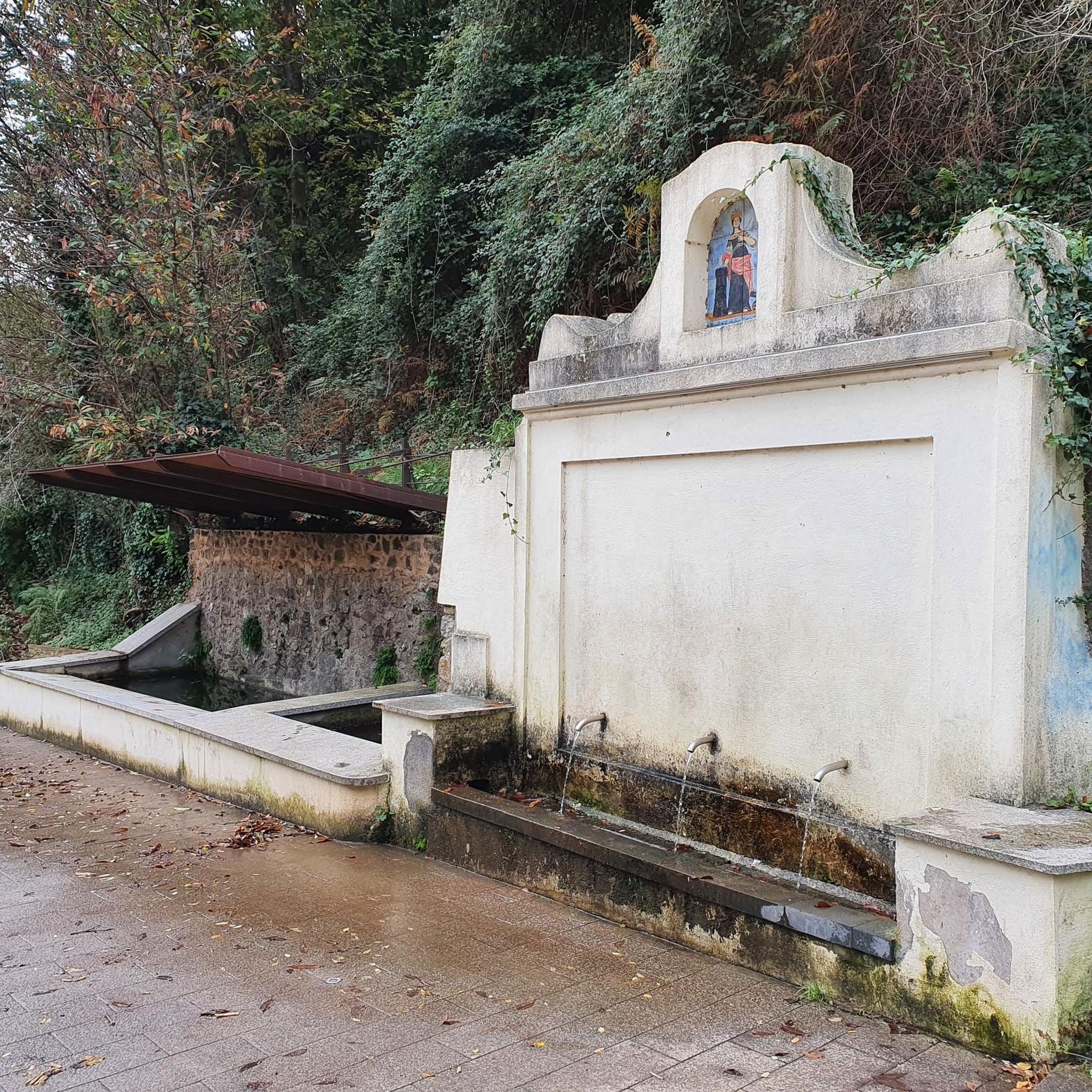
A very pleasant route leads to the gates of the Calabrian Serre crossing the historic Marcellinara gorge and goes up to Caraffa di Catanzaro, a small center of Arbëreshe tradition and, finally, crossing magnificent olive groves, arrives in Girifalco. Here you can admire the so-called "Devil's Fountain", created by Carlo Pacino in the 17th century (it is told in just one night). In Girifalco, a visit to the fabric laboratory of the young Rocco Vitaliano, who also works with broom fibre, is recommended.
4
0

Monte Covello represents the peak of this area and is crossed by many local cyclists who choose to reach it from its southern and northern slopes. The mountain is characterized by lush greenery, so although the panoramic view is not available, the surrounding environment is extremely beautiful and welcoming. Furthermore, the track of the "Alta Via Parchi Calabria" passes right here.
1
0
자주 묻는 질문
아마로니 주변 달리기 코스의 지형은 어떤가요?
아마로니는 올리브 과수원과 계단식 경작지가 있는 구릉 지형부터 고지대의 울창한 참나무와 밤나무 숲까지 다양한 풍경을 제공합니다. 자연스러운 오르막과 내리막이 있어 도전적이면서도 경치 좋은 달리기 경험을 선사합니다. 또한 게테렐로(Ghetterello) 개울의 비옥한 계곡은 흐르는 물소리와 함께 쾌적한 코스를 제공합니다.
아마로니에 순환 조깅 코스가 있나요?
네, 아마로니와 그 주변에는 여러 순환 달리기 코스가 있습니다. 예를 들어, 아마로니 출발 달리기 루프를 따라 5.9km의 보통 난이도 코스를 탐험할 수 있습니다. 다른 옵션으로는 산 비토 술로 이오니오(San Vito sullo Ionio)에서 출발하는 산 비토 술로 이오니오 순환 코스가 있으며, 이는 7km의 보통 난이도 코스입니다.
아마로니 근처에 장거리 달리기 옵션이 있나요?
더 길고 도전적인 달리기를 원하시는 분들을 위해, 카탄차로(Catanzaro)에서 출발하는 지리팔코(Girifalco) – 몬테 코벨로(Monte Covello) 순환 코스는 13.2km의 어려운 코스로, 상당한 고도 변화가 있어 이 지역의 다양한 풍경을 통해 보람 있는 경험을 제공합니다.
이 지역에 초보자 친화적인 쉬운 달리기 코스가 있나요?
아마로니 지역의 많은 코스가 중간 정도의 경사를 가지고 있지만, 코파넬로(Copanello)에서 출발하는 달리기 루프는 더 쉬운 옵션을 제공합니다. 이 코스는 4.1km 길이이며 고도 변화가 최소화되어 초보자나 가벼운 조깅에 적합합니다.
아마로니 주변을 달리면서 볼 수 있는 자연 명소가 있나요?
이 지역에는 여러 자연 명소가 있습니다. 흐르는 물로 유명한 시원한 세라 샘(Serra Spring)이나 고대 동양 플라타너스(Oriental Plane Tree)를 만날 수 있습니다. 폴리올로 샘(Poliolo Spring)은 또 다른 아름다운 장소로 쾌적한 자연 환경을 제공합니다.
달리기 코스에 역사적 랜드마크나 관심 장소가 있나요?
달리는 동안 성 안토니오의 석비(Stele of Saint Anthony)를 지나칠 수 있습니다. 더 광범위한 문화 경험을 위해서는 지리팔코(Girifalco)와 같은 인근 마을을 방문하거나 역사적인 스퀼라체 노르만 성(Norman Castle of Squillace)을 탐험하는 것을 고려해 볼 수 있지만, 이는 직접적인 달리기 경로에서 약간 벗어날 수 있습니다.
아마로니에서 조깅하기 가장 좋은 시기는 언제인가요?
아마로니의 지중해성 기후 덕분에 일년 중 대부분 조깅하기에 적합합니다. 봄과 가을에는 쾌적한 온도와 생동감 넘치는 풍경을 즐길 수 있습니다. 여름에도 이른 아침이나 늦은 저녁은 이상적이며, 특히 그늘진 숲을 통과하거나 게테렐로(Ghetterello) 시냇물 계곡을 따라가는 코스에서 더욱 그렇습니다.
이오니아 해안이 보이는 경로가 있나요?
아마로니는 스퀼라체 만(Gulf of Squillace)이 내려다보이는 푸른 언덕에 자리 잡고 있습니다. 해안 바로 옆에 있는 특정 경로는 여기에 자세히 나와 있지 않지만, 내륙의 많은 지방 도로는 작은 마을과 마을을 연결하면서 바다가 언뜻 보이는 등 아름다운 경치를 제공합니다. 다양한 고도는 종종 탁 트인 전망을 제공합니다.
아마로니는 고저차가 있는 트레일 러닝에 좋은 장소인가요?
물론입니다. 아마로니의 풍경은 카르보나라 산(Mount Carbonara) 기슭에 위치한 것을 포함하여 상당한 언덕과 산으로 특징지어집니다. 이는 올리브 나무 숲을 지나는 완만한 경사부터 참나무와 밤나무 숲의 더 도전적인 오르막까지, 역동적인 운동을 보장하는 다양한 고저차가 있는 트레일 러닝에 탁월한 기회를 제공합니다.
아마로니에서의 러닝 경험이 독특한 이유는 무엇인가요?
아마로니에서의 러닝은 자연의 아름다움과 평온함이 독특하게 조화를 이룹니다. 풍부한 지중해 꽃과 허브의 생물 다양성을 경험하게 되며, 이는 이 지역의 '꿀의 도시'라는 명성에 기여합니다. 고요한 언덕, 푸른 숲, 졸졸 흐르는 시냇물 소리는 도시의 번잡함에서 벗어나 상쾌하고 매력적인 환경을 조성합니다.
마을이나 도시를 연결하는 경로를 찾을 수 있나요?
네, 일부 경로는 아마로니와 이웃 지역을 연결합니다. 예를 들어, 세나디(Cenadi)에서 출발하는 산 비토 술로 이오니오(San Vito sullo Ionio) 루프는 이 매력적인 마을들을 연결하는 아름다운 지방 도로를 탐험할 수 있게 해주며, 이 지역의 시골의 아름다움을 다른 관점에서 보여줍니다.
아마로니 주변에서 가장 인기 있는 경로
아마로니 주변에서 가장 인기 있는 명소


더 살펴보기
다른 지역의 최고의 러닝 트레일 & 경로를 살펴보세요.
