ルート

プランナー

機能

アップデート

App

ログインまたはサインアップ

アプリを入手

ログインまたはサインアップ

ルート
Places to see
ポルトガル
グアルダ

エストレーラ山脈

エストレーラ山脈周辺のアトラクション&必見スポット - トップ20


エストレーラ山脈には必見のスポットがたくさんあります。ハイキング愛好家やサイクリング愛好家の方は、ぜひエストレーラ山脈を探索してこのエリアにある20
の隠れたスポットを訪れてみてください。このエリアの必見スポットを確認し、次の冒険に出かける計画を立てましょう。

最終更新日: 7月 6, 2026

コヴァン・ドス・コンショス・トレイル

ハイライト (セグメント) • 自然記念物

We meet a lot of people on the route, especially on August 16, the trail is easy but many areas of scree require good shoes and flexible ankles. The landscapes …

翻訳者 Google •

役立つ情報

によるものです

ここでのハイキングを見る

スマートフォンに送信

保存

ラゴア・コンプリダ

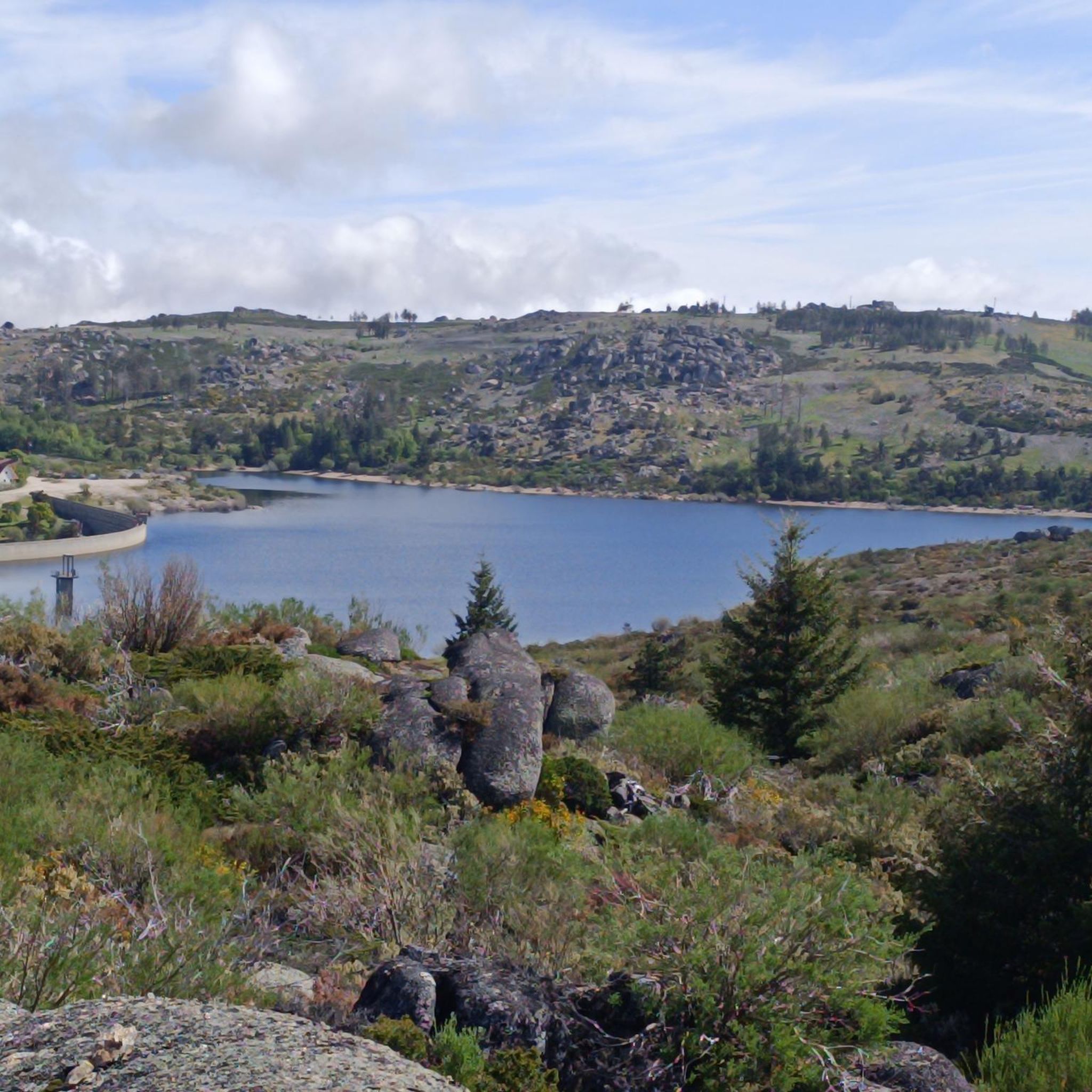
ハイライト • 湖

Located at an altitude of approximately 1,600 meters, Lagoa Comprida is the largest water reservoir in the Serra da Estrela, intended for hydroelectric generation.

翻訳者 Google •

役立つ情報

によるものです

保存

今すぐサインアップして、こんな場所を発見しよう

最高のシングルトラック、ピーク、その他のエキサイティングなアウトドアスポットのおすすめを受け取ろう。

無料新規登録

Praia Fluvial da Lapa dos Dinheiros

ハイライト • ビーチ

Nestled on the banks of the Caniça river, a tributary of the Alva river, this beach area is a haven in the middle of a mountainous landscape, where ancient chestnut trees and granite blocks shape the scenery.

翻訳者 Google •

役立つ情報

によるものです

保存

This is the HP of mainland Portugal. The short way up is to drive up to the top, park up and walk 50m to the summit and then go and buy some good cheese and meats from the summit shops!

役立つ情報

によるものです

保存

At an altitude of 1,700 metres, in the heart of the Serra da Estrela, stands the impressive Nave da Mestra, a granite colossus that holds a centuries-old secret: the Barca …

翻訳者 Google •

役立つ情報

によるものです

保存

At over 1,400 meters above sea level, the Rossim Valley Reservoir is a haven of granite, pine trees, and crystal-clear waters in the heart of the Serra da Estrela Mountains. …

翻訳者 Google •

役立つ情報

によるものです

保存

カンタロ・マグロ

ハイライト • 自然記念物

Cântaro Magro is one of the most iconic and spectacular rock formations in the Serra da Estrela, the highest mountain range in mainland Portugal.

翻訳者 Google •

役立つ情報

によるものです

保存

セーラ・ダ・エストレーラ

ハイライト • 山道

Beautiful panoramic views from the highest point in Portugal. You can ski here in winter, and there is sometimes snow even in summer.

翻訳者 Google •

役立つ情報

によるものです

保存

コルノス・ド・ディアボ

ハイライト • 自然記念物

The enigmatic Devil's Horns rise from the granite, defying the sky with their six-metre height. Sculpted by erosion over the centuries, they earned this bold name thanks to their sharp and imposing profile.

翻訳者 Google •

役立つ情報

によるものです

保存

モンデーゴ川の遊歩道

ハイライト (セグメント) • トレイル

Beautiful Skywalk, still closed but great to commit

翻訳者 Google •

役立つ情報

によるものです

保存

無料でサインアップして、さらに多くの観光スポットを発見しましょう エストレーラ山脈での。

無料新規登録

すでにアカウントをお持ちですか?

無料アカウントで今日から始めよう

次の冒険が待っています。

ログインまたは登録

エストレーラ山脈周辺で人気

歴史的村々を巡るグレートルート(GR22南ループ)-国家誕生

歴史的な村々の偉大なルート(GR22北ループ)-城と渓谷

ポルトガルの山地をバイクパッキング

エストレーラ山脈でのハイキング

エストレーラ山脈のMTBトレイル

エストレーラ山脈のロードバイクルート

エストレーラ山脈のランニングコース

エストレーラ山脈でのサイクリング

エストレーラ山脈でののグラベルライド

エストレーラ山脈でのの他の冒険

歴史的村々を巡るグレートルート(GR22南ループ)-国家誕生

ハイキングのコレクション によって

Bryan | Exploro Ergo Sum

コミュニティからのヒント

Ludgero Guerreiro🇵🇹
1月 19, 2026, Cornos do Diabo

The Devil's Horns are a prominent granite rock formation with two horn-like points, located in the Serra da Estrela mountain range, near Lapa dos Dinheiros and Senhora do Desterro (not in Gerês, but in Seia, Portugal). They are the highlight of a famous circular hiking trail that follows a water channel and the Caniça stream, offering stunning landscapes, lagoons, and waterfalls. 👍🥾

Google翻訳による翻訳

0

0

Cântaro Magro is one of the "commonplaces" of the Serra da Estrela mountain range, whose summit rises to 1928 m altitude, deserving a visit at any time of year. Viewed from west to east, its silhouette resembles a pitcher. In summer, its rocky face is interrupted by small terraces of soil, where some of the rarest botanical jewels of the mountain range grow. In winter, it is covered in snow and ice which, as they melt, form ephemeral waterfalls. These recall the overflowing liquid from the pitchers carried on the heads of women when, in the past, they went to the fountains. #CISE #VisitSeia #ParqueNaturaldaSerradaEstrela

Google翻訳による翻訳

0

0

Covão dos Conchos is an artificial lagoon located in the Serra da Estrela Natural Park, Portugal, near the mountain village of Sabugueiro. Covão dos Conchos became famous for its bell-mouth spillway[1]. The spillway was built in 1955 to allow water to be transferred from the Ribeira das Naves River to Lagoa Comprida. It is part of the Serra da Estrela Hydroelectric System. This science fiction-style spillway became famous when photographs of the hole went viral on social media in 2016. Over the past 60 years, the growth of vegetation at the funnel's mouth has created extraordinary biodiversity and increased its ethereal allure. It is 4.6 meters high and 48 meters in circumference. The tunnel that collects the water is 1,519 meters long.

Google翻訳による翻訳

1

0

The Lapa dos Dinheiros river beach is in perfect harmony with nature. Located in the parish of Lapa dos Dinheiros, on the Caniça River, a right-bank tributary of the Alva River, this bathing area is nestled in a mountainous landscape dominated by the Lapa Souto (south of Lapa) and imposing granite outcrops. With clear water, very appealing for swimming, the beach boasts the award for accessible beach and has lifeguards and a bar available to visitors. The rugged terrain of the valley causes the river to form a succession of small waterfalls nearby. The Lapa Souto, in addition to its valuable collection of centuries-old chestnut trees, is also home to a high level of biodiversity. From the bridge, a pedestrian path leads to the Moura Hole and a viewpoint over the Caniça Waterfalls. The Buraco da Moura is a natural cave system created by the sliding and accumulation of large granite blocks, which formed a complex system of rooms and galleries. How to get there? Once in Seia, follow the EN231 to S. Romão. From there, continue uphill for about 5 km, toward Loriga/Lapa, until you find the sign for Lapa dos Dinheiros on the left. Once inside the town, simply follow the beach signs. Coordinates: 40º 23′ 07.0″ N / 7º 41′ 50.1″ W

Google翻訳による翻訳

1

0

Located within the Planalto Superior biogenetic reserve, the Rossim Valley is a unique location of great scientific, environmental, and scenic value that deserves to be protected and enhanced. Although it is an artificial lake, over time, conditions have been created that have transformed this area into an excellent leisure and recreation area that attracts countless tourists. The Vale do Rossim recreation center is located at an average altitude of 1,437 meters. Before the dam was built, it was one of the best high-altitude pastures in the municipality of Gouveia. The area has almost always been frequented by transhumance herds, flocks that gathered here from São João to the Sr. do Calvário festivities in August.

Google翻訳による翻訳

3

0

A beautiful hike through the valley (depending on your starting point, the ascent or descent will be more pronounced). Start as early as possible, while the sun is still behind the mountain range. Online tickets only (no payment on site). Take a screenshot of your ticket (QR code). This will be scanned when exiting or re-entering (if you want to go back). Bring plenty of water. The sun will come out around 10:00 a.m. (I hiked it in October). Parking is available right next to the upper starting point. The lower trailhead is about 500 meters away (coming from Chãos, turn left before the dam).

Google翻訳による翻訳

2

0

At over 1,400 meters above sea level, the Rossim Valley Reservoir is a haven of granite, pine trees, and crystal-clear waters in the heart of the Serra da Estrela Mountains. It's the perfect setting for strolls, summer swims, and admiring nature in all its splendor, one of Portugal's highest jewels.

Google翻訳による翻訳

3

0

A beautiful nature trail, about 9 km round trip to Covão dos Conchos. Unfortunately, on August 15th, the water couldn't reach the hole and thus reveal the waterfalls. It's a reservoir, part of the Serra da Estrela hydroelectric system. A funnel-shaped drainage structure that allows water to flow from this body of water to Lagoa Comprida. The spillway was built in 1955 to divert water from Ribeira das Naves to Lagoa Comprida. Over the past 60 years, moss and foliage have grown over the mouth of the funnel, creating a captivating spectacle. It is 4.6 meters high and 4.8 meters in circumference. The tunnel that collects the water is 1,519 meters long. It's a stunning place to visit, not only for the combination of human intervention and nature, but also for the surrounding landscape.

Google翻訳による翻訳

2

1

エストレーラ山脈でのの人気ルート

エストレーラ山脈でのハイキング

エストレーラ山脈でのの人気観光スポット

Natural Monuments

Store rating

komootモバイルアプリでインスピレーションを得よう

無料のkomootアカウントがあれば、無限のアウトドアコースを簡単に見つけてカスタマイズし、ナビで案内できます。

または

今すぐkomootに参加しよう

Store rating

さらに探索

まだ探しているハイライトが見つかりませんか?他の地域のトップアトラクションのガイドを見てみましょう:

国立公園エストレーラマンテイガスグーヴェイアSão RomãoMangualde Da SerraセイアManteigas (São Pedro)Alvoco Da SerraLapa Dos DinheirosSabugueiroSeiaValezimCabeçaLorigaSazes Da BeiraVidePaços Da SerraVila Cova À CoelheiraSão MartinhoSanta MarinhaSameiroAldeiasManteigas (Santa Maria)SandomilTorrozeloSantiagoTeixeiraFolgosinhoGouveia (São Pedro)PinhançosFolhadosaCarragozelaVale De AmoreiraMoimenta Da SerraFernão JoanesVidemonteVárzea De MerugeValhelhasFamalicãoセロリコ・ダ・ベイラSeixo AmareloVelaGouveia (São Julião)Meiosビラ・ノヴァ・デ・フォス・コア(Vila Nova De Foz CoaSanta Combaフィゲイラ・デ・カステロ・ロドリゴCadafazPradosRapaMizarelaTrintaVila SoeiroAlmendraSão PaioEscalhãoLinharesVinhóAldeia Do BispoAldeia ViçosaAlvendreCavadoudeCorujeiraFaiaGuarda (São Vicente)Guarda (Sé)MaçainhasPêro SoaresRamelaSão Miguel Da GuardaVale De EstrelaVila Cortês Do MondegoSameiceSalgueiraisVale De AzaresVide Entre VinhasVilar De AmargoMata De LobosCastelo MelhorFigueiró Da SerraPanoias De CimaサブガルBenesperaMeloFreixo Da SerraLajeosa Do MondegoFigueira De Castelo RodrigoピンヘルGonçaloArrifanaCarrapichanaEscarigoフォルノス・デ・アルゴドレスAguiar Da BeiraVila Cortês Da SerraRibamondegoNabaisVila RuivaTouraisReigadaVermiosaトランコソCortiçô Da SerraVila Nova De Foz CôaAlmofalaFóiosアルメイダSortelhaArcozeloメーダNespereiraCastelo BomJunçaNavesAlgodresCastelo RodrigoVila Franca Da SerraSanto AmaroSão Pedro De Rio SecoLagarinhosVilar TorpimChãsMuxagataCinco VilasMalpartidaMurçaSanto EstêvãoMoitaLongroivaFreixo De NumãoMósVale Da MulaSeixasCasteleiroJoão AntãoFreixeda Do TorrãoVale De AfonsinhoPena LoboAldeia De Santo AntónioSoutoSanta CombaAldeia NovaSanta EuláliaCelorico (São Pedro)Quintas De São BartolomeuSabugalVale De CoelhaValdujoCótimosVilar FormosoTouçaLajesAlmeidaÁguas BelasVale De EspinhoQuintã De Pêro MartinsVila BoaQuadrazaisMalcataColmealNumãoCidadelheNaveVale De MadeiraPenha De ÁguiaHortaコア渓谷とシロ公園CustóiasLeomilSenourasFonte LongaAldeia Do BispoMoreira De ReiCasal De CinzaBendadaTravancinhaPorto Da CarneSobral Da SerraVila Do TouroRendoPousafoles Do BispoRuvinaCogulaAguiar Da BeiraPinhelCedovimGuilheiroMalhada SordaBaraçalNave De HaverMesquitelaAlfaiatesFornos De AlgodresAzinhalLombaRocamondoVale VerdeVila GarciaCastelo MendoSequeirosGradizVilar MaiorFreinedaVila Nova De TazemCoriscadaRio TortoAzevoBarreiraCasas Do SoeiroForno TelheiroTrancoso (Santa Maria)Vale Do SeixoTrancoso (São Pedro)TamanhosSouto MaiorPóvoa Do ConcelhoVila Boa Do MondegoJuncaisTorresMidoMêdaRapoula Do CôaMarialvaPevaAldeia VelhaSantana Da AzinhaErvedosaVila GarciaPêra Do MoçoGonçalo BocasAvelãs De AmbomCativelosRuivósBismulaSebadelheAçoresTerrenhoCastanheiraMinhocalBaraçal

近くのアドベンチャーガイド

国立公園エストレーラでやるべきこと

background

新しいピークを征服する準備をしよう

無料でサインアップ

探検する
ルートルートプランナー機能ハイキングMTBトレイルロードバイクルートバイクパッキングサイトマップ
アプリをダウンロード
SNSでフォローする

© komoot GmbH

プライバシーポリシー