ノイルッピン周辺のおすすめシティハイキング&ウォーキング
4.6
(2746)
9,861
ハイカー
57
ハイキング
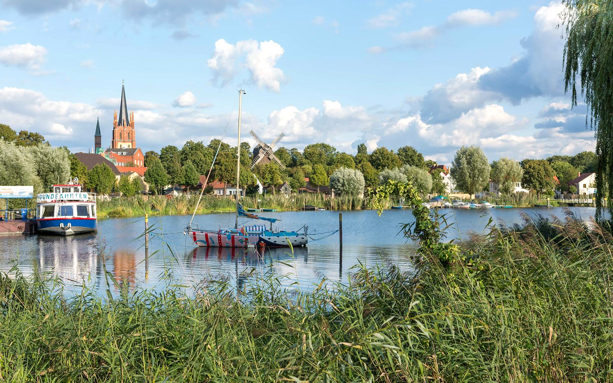
ノイ Ruppin 周辺のアーバンハイキングコースは、街の歴史的建造物と自然環境が融合した多様な景観を特徴としています。この地域は、ブランデンブルク州で最も長い湖である広大なルッピナー湖に面しており、湖畔の遊歩道が数多くあります。都市部を離れると、ルートは近くの森や緩やかに起伏する丘陵地帯に広がり、探索に適した変化に富んだ地形を提供します。
ノイ Ruppin 周辺のベスト・アーバンハイキングコース
- 最も人気のあるアーバンハイキングコースは、桟橋とガゼボ、湖の眺め – ノイ Ruppin からのルッピナー湖ループで、距離は 3.1 マイル (5.0 km)、所要時間は 1 時間 17 分です。このルートからはルッピナー湖の景色を眺めることができ、ガゼボのある桟橋を通り抜けます。
- 地元ハイカーに人気のもう一つのコースは、ノイ Ruppin 市壁 – 旧体育館ノイ Ruppin ループ、ノイ Ruppin Rheinsberger Tor 発で、距離は 6.1 マイル (9.9 km) の中程度の難易度です。このトレイルは、歴史的な街の要素と都市部の緑地を巡ります。
- 地元ハイカーに愛されているのは、ルッピナー湖 – 桟橋とガゼボ、湖の眺めループ、ノイ Ruppin 発で、距離は 2.5 マイル (4.1 km) です。都市部を抜け、湖畔に沿って進むこのコースは、通常約 1 時間 3 分で完了します。
- ノイ Ruppin 周辺のハイキングは、湖畔の遊歩道、歴史的な市壁、都市部の緑地が特徴です。このネットワークは、簡単な散策から中程度の都市探検まで、さまざまなレベルのオプションを提供しています。
- ノイ Ruppin のルートは、komoot コミュニティから高く評価されており、2200 件以上のレビューで平均 4.6 星を獲得しています。8900 人以上のハイカーが komoot を利用して、ノイ Ruppin の変化に富んだ地形を探索しています。
最終更新日: 8月 20, 2026
4.6
(5)
22
ハイカー
初級者向けハイキング. あらゆるフィットネスレベルに適しています。 進みやすいルートです。あらゆるスキルレベルに適しています。
4.8
(4)
37
ハイカー
5.03km
01:17
20m
20m
初級者向けハイキング. あらゆるフィットネスレベルに適しています。 進みやすいルートです。あらゆるスキルレベルに適しています。

無料新規登録
5.0
(3)
16
ハイカー
中程度のハイキング. ある程度のフィットネスレベルが必要です。 進みやすいルートです。あらゆるスキルレベルに適しています。
5.0
(4)
27
ハイカー
5.37km
01:22
20m
20m
初級者向けハイキング. あらゆるフィットネスレベルに適しています。 進みやすいルートです。あらゆるスキルレベルに適しています。
5.0
(1)
21
ハイカー
7.51km
01:55
20m
20m
初級者向けハイキング. あらゆるフィットネスレベルに適しています。 進みやすいルートです。あらゆるスキルレベルに適しています。
さらに多くのルートや他のユーザーのおすすめ情報を確認できます。
無料新規登録
すでにアカウントをお持ちですか?
おすすめのツアーは他のkomootユーザーが実際に経験した何千ものアクティビティに基づいています。
無料アカウントで今日から始めよう
次の冒険が待っています。
ログインまたは登録


コミュニティからのヒント

The city's first fortifications were built during the 13th century using palisades and a rampart and ditch system, which were later replaced by walls and ramparts. Twenty-four watchtowers and two tall towers further reinforced the city walls. Three gates were added: the Altruppin/Rheinsberg Gate in the north, the Berlin/Bechlin Gate in the south, and the Sea Gate in the east. The city was completely encircled by walls towards the end of the 15th century. The city wall is still almost entirely intact today. https://www.goruma.de/staedte/neuruppin/neuruppin-sehenswuerdigkeiten
2
0
A scale model of Neuruppin's old town, built to a 1:1000 level, has been installed right on the school square. This bronze model of the old town, designed for tactile exploration, encourages locals and visitors, sighted and blind alike, to get a feel for the Fontane city of Neuruppin. Streets and landmarks are also labeled in Braille. Here, one can survey Neuruppin's old town with its spacious and uniform layout in the neoclassical style, its three large squares, and its grid-like street plan with houses arranged in blocks. https://tourismus-neuruppin.de/kultur-erleben-neuruppin/sehenswertes-neuruppin/243-stadtmodell-neuruppin
2
0
The school square in Neuruppin is an architectural statement of the Enlightenment – spacious, rational, and still a defining feature of the town's identity. After the devastating town fire of 1787, Neuruppin was redesigned under the direction of the Prussian building inspector Bernhard Brasch. The school square was created as part of a neoclassical town plan characterized by clear axes, symmetrical layouts, and functional spatial arrangements. With an area of over 33,000 m², it is one of the largest town squares in 18th-century Europe. The square was deliberately chosen as the location for educational institutions – including the Old Gymnasium, which is still used as a school building today. This connection between space and educational purpose is an expression of Enlightenment-era urban planning. The surrounding buildings are two stories high and understated in design, giving the square a calm and orderly atmosphere. The expansiveness of the space has an almost meditative effect. The school square is not only architecturally significant, but also a venue for events, markets, and gatherings – a vibrant part of city life. As the birthplace of Theodor Fontane, Neuruppin is steeped in literary traces – the school square also appears in his work as part of the urban landscape. https://de.wikipedia.org/wiki/Neuruppin
2
0
The Wichmann Linden tree in Neuruppin is a living natural monument – a tree that breathes history and enriches the city with its serene presence. This impressive winter linden stands near the city wall by the Neuruppin Monastery Church and is one of the oldest trees in the region. With an estimated age of over 700 years, it is not only a botanical highlight but also a symbol of both continuity and change. The tree is hollow after being struck by lightning, but this does not diminish its majestic appearance – on the contrary: it acts as a venerable guardian of the city's history. https://www.baumkunde.de/baumregister/3327-wichmannlinde_in_neuruppin/
2
0
Lake Ruppin covers an area of 8.25 km² and is 14 km long, making it the longest lake in Brandenburg. Its maximum depth is approximately 24 m. A roughly 25 km long circular path leads around the lake, inviting hikers and especially cyclists to explore. To the south of the lake lies Wustrau, a village of about 1,100 inhabitants, which is well worth a visit. The lake receives its water from the Rhin River via the Zermützelsee, the Tetzensee, and the Molchowsee at the Altruppin lock, and flows into the Bützsee via the Wustrauer Rhin. https://www.goruma.de/staedte/neuruppin/neuruppin-sehenswuerdigkeiten
2
0
フリードリヒ・ヴィルヘルム2世の記念碑は、1787年の大火の後、都市の再建に尽力した元プロイセン王のために、ノイリュッピン市民によって捧げられました。それはノイリュッピンの市内中心部、旧ギムナジウムの向かいにあるシュール広場に目立つように立っています。カール・フリードリヒ・シンケルとクリスティアン・フリードリヒ・ティークによる元の記念碑は、1829年8月26日に除幕されました。現在のフリードリヒ2世の彫刻は、オリジナルを再現したものです。 https://www.wikiwand.com/de/articles/Denkmal_Friedrich_Wilhelm_II.
2
0
The monumental stainless steel sculpture "Parzival am See" (Parzival by the Lake) on the shore of Lake Ruppin is far more than just a work of art; it is a powerful symbol of change and hope. Standing a proud 17 meters tall, Parzival, created by the artist Matthias Zágon Hohl-Stein, was unveiled in 1998 to mark the town's renaming as "Fontanestadt" (Fontane City). The symbolism is particularly striking: In one hand, Parzival holds a windmill, in the other an ark – symbols of progress and preservation. The sculpture represents a new Neuruppin without a garrison, a city on the move, confronting its history while simultaneously looking to the future. An inspiring place that invites reflection – and a fantastic photo opportunity right on the lakeshore. Anyone visiting Neuruppin should definitely take a look at this modern-day knight. https://tourismus-neuruppin.de/kultur-erleben-neuruppin/sehenswertes-neuruppin/119-parzival-am-see-neuruppin
2
0
A stroll to Neuruppin's pier is a true highlight for anyone who loves peace, water, and panoramic views. The path leads along Lake Ruppin, past ancient trees and charming villas, offering frequent glimpses of the shimmering water. The pier itself is a beautiful spot to linger – perfect for a picnic or simply enjoying the view of the old town and its fortifications. The walk is especially lovely in the early morning or at sunset, when the light reflects on the lake, creating an almost magical atmosphere. https://tourismus-neuruppin.de/kultur-erleben-neuruppin/sehenswertes-neuruppin
2
0
よくある質問
ノイリュッピンには、いくつの都市ハイキングトレイルがありますか?
ノイリュッピンには、探索できる50以上のルートがあり、多種多様な都市ハイキングトレイルが用意されています。これらのほとんどは初心者向けとされており、ほとんどのハイカーがアクセス可能です。
ノイリュッピンの都市ハイキングの一般的な難易度はどのくらいですか?
ノイリュッピンの都市ハイキングのほとんどは「易しい」と評価されており、57ルート中53ルートがこのカテゴリーに該当します。もう少し挑戦したい方のために、4つの「普通」のルートもあります。都市ハイキングカテゴリー内には「難しい」ルートは記載されておらず、リラックスした体験ができます。
ノイリュッピンには周回型の都市散策コースはありますか?
はい、ノイリュッピンの都市ハイキングの多くは周回型で、同じ場所からスタートして同じ場所に戻ることができます。例えば、ノイリュッピン発、ガゼボ付き桟橋とリュッピン湖の眺め – リュッピン湖ループは、湖畔に沿った快適な周回散策を提供します。
ノイリュッピンの都市ハイキングでは、どのような自然の特徴が期待できますか?
ノイリュッピンの都市ハイキングでは、ブランデンブルク州で最も長い湖である美しいリュッピン湖(Ruppiner See)が登場することが多く、風光明媚な水辺の景色を楽しめます。また、緑地、公園、魅力的な街並みも目にすることができます。この地域は、自然の美しさと都市の魅力が融合していることで知られています。
都市トレイル沿いには、歴史的建造物や見どころはありますか?
もちろんです。ノイリュッピンの多くの都市ルートは、重要なランドマークを通過します。例えば、ノイリュッピン・ラインスベルガー・トー発、ノイリュッピン市壁 – 旧ギムナジウム・ノイリュッピン ループは、街中の史跡を巡ります。また、近くにはグリーネリック湖(Grienerick Lake)やボベロー樹木園(Arboretum Boberow)のような見どころもあり、この地域の自然遺産を垣間見ることができます。
ノイリュッピンは家族向けの都市ハイキングに適していますか?
はい、ノイリュッピンは非常に家族向けです。湖畔や公園を通る易しいルートが豊富にあるため、あらゆる年齢層に最適です。平坦な地形と整備された小道は、お子様連れの家族にとって快適な体験を保証します。
ノイリュッピンの都市ハイキングに犬を連れて行くことはできますか?
ノイリュッピンの多くの都市トレイルは犬同伴可能で、愛犬と一緒に散策を楽しむことができます。特に人口の多い地域や野生動物の近くでは、リードにつないでおくことをお勧めします。また、特定のルートについては現地の規制を確認するのが良いでしょう。
ノイリュッピンで都市ハイキングを楽しむのに最適な時期はいつですか?
ノイリュッピンでは、一年を通して快適な都市ハイキングが楽しめます。春には自然が芽吹き、夏には心地よい湖畔の散策ができ、秋には鮮やかな紅葉が見られます。冬でさえ、静かで澄んだ空気の中での散策が可能です。それぞれの季節が、街とその周辺にユニークな魅力を提供します。
ノイリュッピンの都市トレイルへの公共交通機関でのアクセスオプションはありますか?
ノイリュッピンは公共交通機関との接続が良好で、多くの都市トレイルに簡単にアクセスできます。ルートは、ノイリュッピン・ラインスベルガー・トー(Neuruppin Rheinsberger Tor)のような中心地の近くから始まることが多く、ここは主要な公共交通機関のハブであり、車がなくても便利にアクセスできます。
ノイリュッピンでの都市ハイキングのための駐車場はどこにありますか?
駐車場は一般的にノイリュッピンの市内中心部とその周辺で利用可能で、都市ハイキングの人気の出発点近くにあります。トレイルへの便利なアクセスのため、リュッピン湖(Ruppiner See)または歴史地区の近くにある指定された駐車場を探してください。
他のハイカーはノイリュッピンでの都市ハイキングで最も楽しんでいることは何ですか?
komootコミュニティはノイリュッピンでの都市ハイキング体験を高く評価しており、平均スコアは4.56つ星です。レビューでは、美しい湖畔の景色、街の歴史的な魅力、そして自然と都市探索を融合させた、易しく整備された小道のアクセスの良さがしばしば称賛されています。
リュッピン湖(Lake Ruppin)の景色を楽しめる都市ルートはありますか?
もちろんです。ノイリュッピンの多くの都市ルートは、見事なリュッピン湖(Ruppiner See)を見せるように設計されています。例えば、ノイリュッピン・ラインスベルガー・トー発、リュッピン湖 – 旧ギムナジウム・ノイリュッピン ループは、広大な湖の景色を楽しむ絶好の機会を提供します。
ノイルッピンでのの人気観光スポット

komootモバイルアプリでインスピレーションを得よう


さらに探索
他の地域の最高のハイキングを見てみましょう。
