Deerのおすすめツーリングルート
4.8
(41)
413
ライダー
69
ライド
Deerでおすすめのサイクリングルートをお探しですか?行きたいルートを簡単に決められるように、このページではDeer周辺の人気バイクライドをご紹介します。 ぜひ、お気に入りのルートを見つけてください。
最終更新日: 10月 16, 2026
5
ライダー
22.3km
01:37
140m
140m
初級者向けバイクライド. あらゆるフィットネスレベルに適しています。 全般的に舗装された状態です。あらゆるスキルレベルに適しています。
5.0
(1)
31
ライダー
98.1km
07:58
540m
540m
難しい自転車ライド. 標準以上のフィットネスレベルが必要です。 全般的に舗装された状態です。あらゆるスキルレベルに適しています。

4.3
(3)
23
ライダー
51.1km
03:58
230m
230m
中程度の自転車ライド. ある程度のフィットネスレベルが必要です。 全般的に舗装された状態です。あらゆるスキルレベルに適しています。
3.9
(7)
17
ライダー
38.9km
03:15
160m
160m
中程度の自転車ライド. ある程度のフィットネスレベルが必要です。 全般的に舗装された状態です。あらゆるスキルレベルに適しています。
18
ライダー
20.5km
01:46
100m
100m
初級者向けバイクライド. あらゆるフィットネスレベルに適しています。 全般的に舗装された状態です。あらゆるスキルレベルに適しています。
さらに多くのルートや他のユーザーのおすすめ情報を確認できます。
すでにアカウントをお持ちですか?
おすすめのツアーは他のkomootユーザーが実際に経験した何千ものアクティビティに基づいています。
無料アカウントで今日から始めよう
次の冒険が待っています。

コミュニティからのヒント

Buckie Farmは2026年6月にファームショップとカフェをオープンしました。朝食、ランチ、ケーキ、アイスクリーム、コーヒーを取り揃えています。屋内席と屋外席をご利用いただけます。Formartine and Buchan Wayへの直接アクセスがあります。散歩やサイクリングの休憩に最適です! 年中無休。 https://buckiefarm.co.uk/buckie-farm-newmachar-cafe/
0
0

perfect for beginners like myself and wife, we would have gone further if we had more time👌
0
0
The Formartine and Buchan railway line connects Dyce in Aberdeen to Fraserburgh and Peterhead. It's a popular path with cyclists, joggers, dog walkers, horse riders etc. Some sections are nice and wide, while others are more single track. There are a number of gates on the route, which are quite narrow. The path is slowly being improved in sections to facilitate better access.
0
0
The Formartine and Buchan cycle and walking trail crosses the River Don here. You can see a gauging station just upstream, past the power lines.
0
0

The 2.5-mile (4 km) walk from Mintlaw to Longside along the Buchan and Formartine Way is a pleasant walk through nature with interesting historical touches. The only drawback is the noise from the nearby Longside Peterhead road. Along the way, you'll notice diverse trees like rowan, elder, and hawthorn. Keep an eye out for historic features like Bridge 718 with remains of telegraph wires. Approaching Longside, the trail passes through fields on an embankment covered with willows. Look out for Longside Station with its overgrown platforms.
0
0
Here the trail ducks under a low tunnel, an arch that is part of Auchlee Bridge carrying traffic over South Ugie Water and the Buchan and Formartine Way in Longside. The granite steps up the bridge leading from the path to the road show signs of quarrying.
0
0
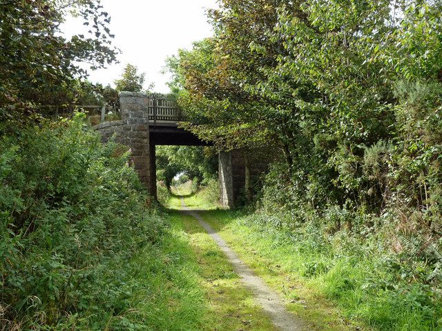
Situated between Old Deer and Mintlaw, Deer Bridge carries traffic over the Buchan and Formartine Way. This bridge would have been close to the former station of Mintlaw, located a few metres to the east of the bridge.
0
0
Maud, formerly known as Brucklay is a quaint village that once served as a crucial junction for the Fraserburgh and Peterhead railway lines. The station, a lasting testament to its historical significance, now houses the Formartine & Buchan Railway Museum. Note that the museum operates seasonally during the summer, so it's advisable to check the opening times before planning your visit.
0
0
Deerの人気観光スポット

komootモバイルアプリでインスピレーションを得よう


さらに探索
他の地域の最高のサイクリングルートを見てみましょう。
